Applications for construction and engineering workflows
XGameDev develops custom applications for architecture, engineering and construction teams. We connect 3D models and their property data to the tasks people need to complete: inspect a building, isolate a trade, measure a distance or record a review comment.
Our work uses Unity for interactive 3D, with model export tooling and application integration where required. We are based in Australia and work with clients internationally. You can engage us for a viewer component, a model pipeline or an agreed application scope alongside your existing team.
V2E: model review for estimators and site teams
For Vision 2 Estimating, XGameDev worked as a subcontractor to Transformr. We built a Unity viewer for SketchUp-derived building models, a SketchUp Ruby export plugin and the Unity side of the WebGL communication bridge.
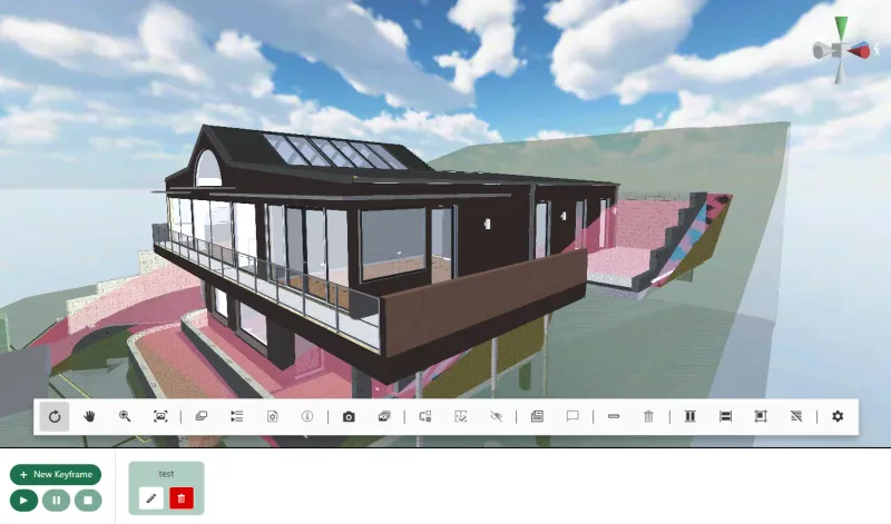
The viewer lets users inspect geometry by layer and cost code, select elements, measure distances, take cross-sections and attach comments. Camera animations and screenshots support review and presentation. The same Unity project supports WebGL, Android and iOS delivery.
XGameDev also built the initial Node.js, MongoDB and Angular prototype. Another team developed the production Angular application and its side of the bridge; the final production build ran on the client's Azure server. The case study describes that division of work.
Architecture and model communication
An architectural application may need a walkthrough, saved views or a way to explain selected parts of a design. The model's geometry, materials and property structure determine how we prepare it for interaction.
We start with the source files and the questions users need to answer. The work can include export tooling, a viewing interface and model navigation. Where required, we preserve selected metadata through an agreed conversion pipeline and test it against the source.
Engineering and spatial data
Engineering applications can combine model data with location or infrastructure information. Our GIS consulting work for Aerobo includes OpenStreetMap and Unity-related mapping technologies. The GIS and engineering visualisation service explains the spatial-data side of the offer.
A geospatial brief should identify the coordinate system, data source, update frequency and the attributes people need to inspect. We assess representative datasets before agreeing format coverage or performance targets.
Construction model inspection
For construction teams, a useful tool keeps the selected building element connected to its information. V2E demonstrates layers, cost-code data, measurements and annotations inside one viewer.
Our 3D model viewer development service covers those inspection tools in detail. We can develop the viewer alongside your application team, agreeing the model-loading API, authentication and communication between the viewer and the surrounding interface.
Model formats and platform choices
Our documented SketchUp pipeline exports glTF/GLB geometry and accompanying metadata into Unity. Other CAD or BIM formats require a sample-based assessment: source properties, conversion tools and licensing can affect what survives the process.
Browser delivery lets users open an application from a link. Installed mobile builds can suit a different workflow, with their own device testing and release requirements. Model size, memory use and the required interactions determine what will work on the target hardware.
For an interactive presentation brief, see 3D visualisation. For a wider connected product, see custom application development.
Start with a representative model
Send one typical source model, the properties users need to inspect, the target devices and a description of the workflow. Include a larger or more demanding file if it represents normal use.
The first milestone can test the export pipeline and a core interaction on that sample. We then agree acceptance checks for geometry, metadata, measurement behaviour, loading and model updates before extending the build. Any engineering calculation or design-validation requirement needs its own specification and subject-expert review.